Book
Displaying items by tag: Beavercreek

The wooded area on either side of Dayton-Xenia Road is the 44.439 acre Ferguson Land Laboratory. The Fergusons were prominent farmers since the settling of Beavercreek and by the 1940’s were the largest growers of potatoes in the area. They donated this land to the Board of Education with the stipulation that it remain forever untouched woodland.
Completed in 1954, the present Beavercreek High School was built adjacently upon 33 acres of Ferguson land that was purchased by the Board of Education and the Ferguson Hall Campus behind sits on another sixteen acres that was donated by brother and sister Edwin and Lida Ferguson.
 BHS Looking East
BHS Looking East
BHS Looking East
 BHS 1966
BHS 1966
BHS 1966
 BHS 1978
BHS 1978
BHS 1978
 BHS 1983
BHS 1983
BHS 1983
 BHS Under Construction
BHS Under Construction
BHS Under Construction
 Banned At BHS
Banned At BHS
Banned At BHS
 BHS
BHS
BHS
BHS
https://beavercreekliving.com/book/itemlist/tag/Beavercreek?start=20#sigProId0f841e7f4d

Please turn right at the stoplight onto Dayton-Xenia Road. In 1887, Beavercreek High School opened, the second high school in the state. Twenty pupils enrolled and classes were held on the second level of the old Stage Coach Inn while the new building was under construction.
Upon completion in late 1888, the students marched their tables, chairs, and books up the street to the new building. This new school gave the students a lot more room. Instead of a whole 'grade level' being at one table, there were only four students to a table.
The south room was used for Freshmen and Sophomores, the north for Juniors and Seniors. Upstairs, smaller rooms were used for smaller classes. In 1914, two more rooms, one for science and one for home economics, were added to the west end of the building to accommodate the increasing population. The first class to graduate from Beavercreek High School was in 1891 with eleven students.
Just to the southeast of the school, pictured below c.1930, is the vocational and agricultural classroom which also served as a horse barn and farrier shop.
In 1915, two more rooms were added. The school was eventually outgrown and moved a bit west.
 First Graduation
First Graduation
First Graduation
 1888 BHS 1
1888 BHS 1
1888 BHS 1
 1888 BHS 2
1888 BHS 2
1888 BHS 2
 Reunion of Old Beaver
Reunion of Old Beaver
Reunion of Old Beaver
 BHS And Vocational
BHS And Vocational
BHS And Vocational
 Class Photo
Class Photo
Class Photo
 Lamachys Menu
Lamachys Menu
Lamachys Menu
 Don't Get Shook
Don't Get Shook
Don't Get Shook
https://beavercreekliving.com/book/itemlist/tag/Beavercreek?start=20#sigProId29d3b67f3d

As you continue south on Beaver Valley Road, look to your right as you exit the s-curve, this was another stone quarry that provided stone for the eastern portion of the township. Local men and boys would hand shovel and deliver stone slabs and gravel from the quarries to earn additional money.
This quarry was located on the Jacob Herring farm in 1874.
https://beavercreekliving.com/book/itemlist/tag/Beavercreek?start=20#sigProId2eac0e7f40


The second 90° turn is home to the William Tobias House at 2057 Beaver Valley Road, built about 1820. Formerly known as Broadview Farm, this is located on an old Shawnee Indian trail. William Tobias had been a tenant farmer in Sugarcreek Township and purchased a log home and 86 acres in 1869. He replaced it with a two-story mortised and pinned frame structure prior to 1879.
The William Tobias House is now owned and maintained by local developer, Bob Mills.

There are numerous stories of haunting in Beavercreek; one takes place just to the northeast of here! If heading to the former town of Byron, Trebein road is haunted by the ghost of a woman who was flung from her carriage after it hit a rock and died (on her wedding day). Her father and fiancée dug up the rock and tossed it to the side of the road where it remains today. She is seen wearing her white wedding dress, often near the time of her anniversary or birthday. Some believe that if you stop and she touches you that you will become old and she will be young and beautiful again. We’ll avoid the area to help preserve your youth – just in case!
Share your stories below!
We’ll be heading south, but it’s interesting to note that at the slight left jog in the road on the west side of Beaver Valley Road at 2533 was the Howard wagon shop in 1855. Later, in 1874, the land was owned by Sam Cosler. The land east of Beaver Valley is now known as the Siebenthaler Nursery. Please turn right and head south on Beaver Valley.
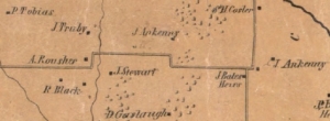
Continue east on Kemp Road through two 90° curves. The rural land in this area was settled by the Ferguson, Stewart, Gerlaugh, Ankeney and Tobias Families and later some was purchased by the Howard, Greene and Bates’. Near the second set of 90° curves are several large-tract estate lots.
On the left is the 80+ acre ‘Russ Property’ that was the homestead of local businessman and philanthropist Fritz Russ. He donated his land to Greene County, it's now known as the 'Russ Nature Reserve'.

When you reach the stoplight at Kemp Road, turn right. Just to the east on Kemp, across from Jacavanda Drive was the residence and gunshop of Sam E. Tobias, Inventor. Considered a genius by many, Sam was a chief consultant to Winchester, Remington, Colt, and Ithica fire arms companies as well as a personal acquaintance of Henry Ford. Sam was integral to the development of ballistics and was revered as one of the greatest gunsmiths around.
"Tobe", as Sam was known, reportedly worked on guns for Wild Bill Hickock and Annie Oakley as well as fashioning a gun for Henry Ford from the axle of a Model T! Death claimed Tobias on November 11, 1927 after he developed an infection following the removal of some teeth.
The Beavercreek Chronicles (pages 157-160) offers great insight into one of the area’s most humble heroes who often shared ideas with others that made THEM rich, for Sam truly believed that money was the root of all evil. Should you ever stumble upon a firearm stamped S.E. Tobias or a book entitled, Sam Tobias the Gunsmith by Gail Tobias Dorsey – buy them!
 Sam Tobias
Sam Tobias
Sam Tobias
 SE Tobias Guns
SE Tobias Guns
SE Tobias Guns
 Sam and Bessie Tobias
Sam and Bessie Tobias
Sam and Bessie Tobias
 Sam Tobias Pistol
Sam Tobias Pistol
Sam Tobias Pistol
 Sam E. Tobias
Sam E. Tobias
Sam E. Tobias
https://beavercreekliving.com/book/itemlist/tag/Beavercreek?start=20#sigProId81f834433f

On your left at 2017 Hanes Road is a home that Greene County dates to 1864, the year prior to Lee’s surrender to Grant at Appomattox Court House.
The owners home was sold to a developer in 2015.
 BHS Placard
BHS Placard
BHS Placard
 Former Kitchen
Former Kitchen
Former Kitchen
 Former Kitchen
Former Kitchen
Former Kitchen
 Dining Room
Dining Room
Dining Room
 Parlor
Parlor
Parlor
 Owner's Suite
Owner's Suite
Owner's Suite
 Summer Kitchen
Summer Kitchen
Summer Kitchen
 Upper Landing
Upper Landing
Upper Landing
 Bedroom
Bedroom
Bedroom
 Privy
Privy
Privy
Privy
 Corn Crib
Corn Crib
Corn Crib
 Headstone
Headstone
Headstone
https://beavercreekliving.com/book/itemlist/tag/Beavercreek?start=20#sigProId172e857fdb

At the base of the hill, you’ll cross the low bridge over the Big Beaver Creek, followed by the Siebenthaler Fen and parking lot. This is a central access to the Beaver Creek Wetland Wildlife Area and the Koogler Wetland / Prairie Reserve, 725 acres within the Township managed by the Beaver Creek Wetlands Association. It’s a beautiful place for a walk, you’ll surely catch a glimpse of some local birds and wildlife!

Proceed straight through the intersection onto Hilltop Road. F.C. Trebein’s home, previously occupied by the Frost family, had been an inn and the stage coaches used to stop there. It was formerly addressed as 1438 Dayton-Xenia Road and is now located on Hilltop Road. In the 1950’s his home was converted to a restaurant and bar known as the Trebein Manor.
Babe's Trebein Tavern at the northwest corner of the train tracks was a popular destination before a fire caused its closure.
Here you can see where the old one-lane bridge from Trebein was removed. From Trebein you cross large tracts of land owned by the Andrews, Fogle, and Burrows families throughout the years and currently by the Nutter family. The Burrow’s home still stand at 1351 Hilltop Road and pre-dates 1874 and possibly 1855!
 Trebein Manor Fire
Trebein Manor Fire
Trebein Manor Fire
 Trebein Tavern Fire #1
Trebein Tavern Fire #1
Trebein Tavern Fire #1
 Trebein Tavern Fire #2
Trebein Tavern Fire #2
Trebein Tavern Fire #2
 Trebein Tavern Fire #3
Trebein Tavern Fire #3
Trebein Tavern Fire #3
 Trebein Tavern Fire #4
Trebein Tavern Fire #4
Trebein Tavern Fire #4
 Trebein Tavern Fire Article
Trebein Tavern Fire Article
Trebein Tavern Fire Article
https://beavercreekliving.com/book/itemlist/tag/Beavercreek?start=20#sigProId4c2abaa17f

Head left (east) on Dayton-Xenia Road. On your right is the combination of Jacob Coy Middle School and Trebein Elementary, completed for the 2013-14 school year. Continue east on Dayton-Xenia Road. Having just past Beavercreek’s newest schools, let’s reflect on some of the past.
As previously mentioned, the first school was on Jacob Coy’s land near the present intersection of Homeway and Towncrest Drives. The second log schoolhouse was southwest of the intersection of Beaver Valley and Lantz Roads. The third, built in 1817 and a fourth log school was built within two years near Beaver Church, in 1822 it was replaced with a brick building. Between 1850 and 1880, the Union School, sometimes called Old Beaver, was the outstanding school in the county.
The curriculum was designed for those aspiring to college including algebra, trigonometry, geometry, analysis of the English language, Latin, Greek and physics. The head teacher, John W. Miller, was so thorough that students who completed the coursework entered Miami University as sophomores! Union School closed in 1882, there is a granite marker behind Beaver Church marking its location.
Several years prior to the Civil War, thirteen school districts were established in the township offering instruction for grades one through eight. Under the direction of Professor W.W. Donham, Beavercreek became the first graded rural district in the state.

https://beavercreekliving.com/book/itemlist/tag/Beavercreek?start=20#sigProIdd6774a07e0

At 1035 Ankeney Road you’ll find the Albert Ankeney House. Built in 1872 by Albert Ankeney Sr., grandson of pioneer David Ankeney, it is of the Italianate style designed by renowned Dayton architect M. Borrow. The limestone came from the Archer quarry and all 66,000 bricks were fired onsite.
This is the grandest and best preserved of all the Beavercreek historic homes and retains its original charm and glory.
https://beavercreekliving.com/book/itemlist/tag/Beavercreek?start=20#sigProId792b509b91


As you approach the next intersection, note that the beautifully restored ‘Centre at Stonehill Village’ is a converted bank barn from the A.M. Suman and later Ankeney farm on Trebein Road. It has found new life as the community center for this wonderful neighborhood.
Turn left onto Ankeney Road.
https://beavercreekliving.com/book/itemlist/tag/Beavercreek?start=20#sigProId82ed16eeda


Return west on Dayton-Xenia Road, turn north Trebein Road, across the Little Miami River. Proceed straight through the intersection at Dayton-Xenia Road. On your right, the residence at 942 Trebein Road was the former Trebein School.
 Trebein School #6 Class Picture
Trebein School #6 Class Picture
Trebein School #6 Class Picture
 Trebein School #6
Trebein School #6
Trebein School #6
 Trebein School as a residence
Trebein School as a residence
Trebein School as a residence
https://beavercreekliving.com/book/itemlist/tag/Beavercreek?start=20#sigProId455c018b90

On the downslope you’ll see a northern and southern access road into the Valley View Memorial Cemetery, look to your left between them and you’ll find a very old log cabin that we don’t know a great deal about. It appears on the 1855 map with the name A. Russell (likely Adam Sr. 1771-2/10/1857, his father Joshua served in the Revolutionary War) attached and the 1874 map on the 100-acre property of J. Russell (likely Joshua Sr. 1810-10/17/1879 or Joshua Jr. 1826-10/17/1857).
The Russell Cabin is in pretty rough shape, if interested in seeing it, expediency is recommended. This is private land, so please do not trespass.
Much of the surrounding land was owned in 1874 by John C. Allen and later the Steel and Flynn families.

Turn left onto Upper Bellbrook Road, the beautiful brick home at 1630 Upper Bellbrook Road is on the 1855 Township map as the farm and orchard of John Ginn, here is his obituary:
John Ginn, farmer, was born on the place on which he now resides, February 24, 1815, and is a son of Thomas and Rachel (Neal) Ginn. His father was born in Ireland; his mother in Kentucky. When a young man, his father emigrated to America, and located in Kentucky, where he was married to Rachel Neal. Several years after-in 1814-he came to this county, and located where our subject now lives, purchasing one hundred acres of wild military land. He was successful in life, and accumulated enough to enable him to live comfortably and pay for his land, which cost him $250, and is now worth $10,000. A year previous to his death he removed to Xenia, where he died at the age of eighty-four years. Mrs. Ginn died in 1830, in the prime of her womanhood. They were the parents of fourteen children, of whom three are living: Robert, John, and Ann. Our subject was raised on the farm, and in 1838 married Jane Hamilton, who has borne him four children, two of whom are living: Rachel, and James H. The deceased are William and Thomas W. After his marriage he worked for some years at different places, and finally purchased the old homestead. He owns one hundred and fourteen acres of land. Mr. and Mrs. Ginn are members of the United Presbyterian Church, with which they have been connected for many years. His parents were members of the old Seceder Church.

The Narrows Reserve is along the Little Miami River is before you at the intersection and offers fantastic hiking through both riverbank and meadow environments. The bridge on your left was originally a long, covered bridge over the Little Miami River. The covered bridge was located just south of the existing bridge and crossed much closer to the river.
 Indian Ripple Bridge
Indian Ripple Bridge
Indian Ripple Bridge
 Indian Ripple Covered Bridge Painting
Indian Ripple Covered Bridge Painting
Indian Ripple Covered Bridge Painting
 Indian Ripple Covered Bridge
Indian Ripple Covered Bridge
Indian Ripple Covered Bridge
 Indian 'Riffle' Road Bridge
Indian 'Riffle' Road Bridge
Indian 'Riffle' Road Bridge

https://beavercreekliving.com/book/itemlist/tag/Beavercreek?start=20#sigProId6bdc13b382

Prior to U.S. Route 35, turn left on Heller Drive and then right on Orchard Lane. Cross U.S. Route 35 and turn right on Yellow Brick Road.
The bridge over the Beaver Creek is the approximate location of Mr. Harbine’s distillery. The mill dam, just north of the existing highway, divided a mill race from the main creek. With this rudimentary dam they could control the flow to the water wheels that powered the mills. Once the mill era passed, the new leg was filled in, and is somewhat viewable in the basin on the north side of the bridge.
Construction of the US-35 highway completely altered the land as it was, but remnants of the mills can still be found just below the surface!
The Harbine Distillery was initially constructed during a time when distilling was an accepted and honored profession. Grist and saw-milling, hog raising, and pork packing were ancillary industrial concerns that made efficient use of the infrastructure and byproducts of the distilling process. Temperance and the development of a widespread and functional railroad system precipitated the decline of this industrial system by the mid-1800s. The crushing blows to rural distilling occurred during the Civil War, when federal excise taxes soared from nothing to $2.00 per proof gallon on whiskey and other distilled spirits. By 1868, when the excise taxes were finally reduced, most of the rural whiskey making ventures had either suspended production or simply ceased. The advent, operation, and demise of the Harbine Distillery parallels the once widespread rural practice of whiskey distilling, an extinct and largely forgotten feature of the American landscape.
** Below you can download a copy of 'The Distiller's Tale' - an archaeological dig at the Harbine distillery **
https://beavercreekliving.com/book/itemlist/tag/Beavercreek?start=20#sigProId251ea64e4d

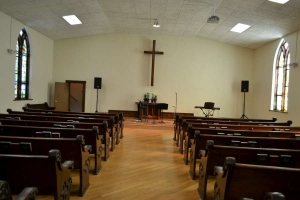
Note the uniqueness and charm of the architecture as you turn right and head through town! Alpha Church, on the east side of Alpha Road, was established in 1872 with our old friend Daniel Overholser, Sr. being a founder and early supporter.
In the past few years, the church has undergone extensive restoration with great attention paid to the tradition of it's founding.
The church is now a campus of the Beavercreek Church of the Nazarene. We'd like to extend a 'thank you' for their willingness to allow the Alpha Historic Society to maintain their archives in the lower level of the church!
 Alpha Church Restoration 1
Alpha Church Restoration 1
Alpha Church Restoration 1
 Alpha Church Restoration 2
Alpha Church Restoration 2
Alpha Church Restoration 2
 Alpha Church Restoration 3
Alpha Church Restoration 3
Alpha Church Restoration 3
 Vacation Bible School
Vacation Bible School
Vacation Bible School
 Vacation Bible School 1922
Vacation Bible School 1922
Vacation Bible School 1922
https://beavercreekliving.com/book/itemlist/tag/Beavercreek?start=20#sigProId04411267e9

The adjacent property, 2358 Dayton-Xenia Road, is affectionately known as The Old Stage Coach Inn. A popular stopping place between Yellow Springs and Dayton, it offered a livery stable for 12 to 14 horses. Built in 1810 by Frank Stoll, it is a modified Vernacular style. Built beside an Indian trail, and also thought to have been a slave trail, the house has a small dirt dugout with a small entrance door under the living room floor; it could have easily hidden three or four people.
Folklore includes a story of Abraham Lincoln once staying overnight at the inn while touring the area on his 1859 Presidential campaign, but research has proven this to be untrue. Lincoln's train did make a 5 minute whistle stop in Xenia before proceeding through Alpha enroute to Dayton, where he gave a sparsely attended speech at the courthouse. Later that evening, Lincoln delivered a modified speech in Cincinnati that changed the course of his campaign to become the sixteenth president of the United States.
In 1887, while the new high school was under construction, classes for the 20 pupils were held in an upstairs room of the Inn. In 1900, it was purchased as a blacksmith shop by Charly Johannes.
 Charly Johannes Receipt
Charly Johannes Receipt
Charly Johannes Receipt
 Marshall Brothers Ad
Marshall Brothers Ad
Marshall Brothers Ad
 Stagecoach House
Stagecoach House
Stagecoach House
 Stagecoach House And Family
Stagecoach House And Family
Stagecoach House And Family
https://beavercreekliving.com/book/itemlist/tag/Beavercreek?start=20#sigProId7add6a246e
Navigation
Latest Blog Posts
- Just Don't Call Us Late For Dinner...
- Remember When...
- What A Long, Strange Trip It's Been...
- Snow Down = Slow Down
- School Bus Safety - Just Do It!
- Stevenson Road Covered Bridge
- Our Road Crews Are Worth Their Salt!
- The Most Colorful Of Seasons!
- Popcorn Fest! - Then And Now
- Pre-School Paradise!
- Remembering Riffles
- Ten Year Anniversary Of The Beaver Statues
Featured Image