Book

On the east side of County Line Road you’ll find Mount Saint John, a 150-acre Marianist property where the Bergamo Center resides. The original 80 acres of Mount Saint John were Shaker lands purchased by the Marianists in 1910. The Marianist Environmental Center is an organization dedicated to increasing awareness of the Earth and natural resources by sustaining appreciation for its preservation.

Watervliet Shaker Village was a Shaker community located in Kettering, Ohio from 1806-1900. Its spiritual name was Vale of Peace and it was within the Union Village bishopric, or governing body. The community was founded by many discontented members of the Beulah Presbyterian church and was named for the first Shaker community in the United States, Watervliet Shaker village in New York. The village at its peak had 100 residents, and it spanned 800 acres. It produced and sold farm produce, garden seeds, and stocking yarn. Among the first Euro-Americans to arrive in this area were John H. Patterson and his family who provided the land on which the Watervliet Shaker Community was founded in 1806.
The village closed in 1900 and the remaining residents moved to the Union Village Shaker settlement in Lebanon, Ohio. The village was sold to the State of Ohio. It was a State Hospital Farm until 1981 when the land in Montgomery County was deeded to the Miami Research Foundation. The land in Greene County had primarily been used for Mount Saint John. Papers, diaries, photographs and books of the village history are archived at the Dayton Metro Library in the 'Shakers Collection'.
https://beavercreekliving.com/book/itemlist/user/23-brettwilliford?start=130#sigProId2f84a7e8f9


Welcome to Shakertown! The Shakers were a religious sect that practiced celibacy, communal living and equality of the sexes in their leadership. The actual name of the sect was The United Society of Believers in Christ’s Second Appearing, but they became known as Shakers due to the energetic dancing included in their worship services. The community, named Watervliet, extended into both Montgomery and Greene counties and was founded by a wheelwright named John Huston.
The Shakers were significant contributors to early American life having invented the circular saw, flat broom and clothes pins. Locally they were respected as hard working, peaceful and sincere people, supporting their commune with produce farming, the packaged seed industry, and Shaker-style furniture. Their 160 acre tract in Greene County was primarily located along County Line Road at the current locations of the Mount St. John / Bergamo Center and the Research Park lands.

The northeast corner of this intersection was the location of the Dayton and Xenia Traction Power Station. Part of the building may have survived to become a portion of the Lammer's Chemical Company, also impactful to Beavercreek's more recent history - but more on that in a bit!
Please turn right at the stop sign onto Patterson Road. The field on your left was once a huge apple orchard. This stretch of East Patterson Road provides some of the most beautiful autumn colors during ‘Peak Week’ – typically late October or early November. The home at 4362 East Patterson Road dates prior to 1880 and was owned by John Moler – more on him in just a moment.
 Dayton and Xenia Traction Power Station
Dayton and Xenia Traction Power Station
Dayton and Xenia Traction Power Station
 Dayton Xenia and Belpre Railroad Stock
Dayton Xenia and Belpre Railroad Stock
Dayton Xenia and Belpre Railroad Stock
 Rapid Transit Company Transfer Ticket
Rapid Transit Company Transfer Ticket
Rapid Transit Company Transfer Ticket
https://beavercreekliving.com/book/itemlist/user/23-brettwilliford?start=130#sigProIde8b5d4c7d3

The second, and more successful mass transit line was The Dayton and Xenia Traction Company, although there were numerous owners and names that followed. We'll refer to this company as 'The Traction' as it was 100+ years ago. Carrying its first passengers on January 23, 1900, its route cut through farmland, roughly following Main Street out of Xenia to Trebein, south of the railroad tracks.
It looped to the south side of the town of Alpha, followed the train tracks to Shoup's Station and ultimately to this point (the car barn was located at the site of Lyndon's Automotive on the southeast corner), the location of the car barn and power station. From here, it proceeded west via Watervliet, Wayne Ave., Phillips Avenue and then Wyoming Street to South Main Street in Dayton.
To stop the trolley, one just stood by the side of the track and signalled the oncoming trolley with a wave of the hand.
Per Elizabeth Shoup-Belden: "January 29, 1900, the noon car on its route to Dayton had failure of air brakes when going down Phillips Avenue hill jumped the tracks at the foot of the hill. There were about twelve passengers aboard. Among the passengers were two young ladies, very close friends, who had boarded the trolley at Alpha. These two, Mill Hallie Klunk and Miss Jeanette Hagenbuch, were seated together, Hallie by the window. When the trolley left the track, Miss Klunk was thrown through the window and fatally injured. Miss Hagenbuch was miraculously saved, receiving only minor bruises.
Mr. Fred Hawker, a farmer living near Alpha, was also fatally injured. There were other serious injuries, especially the motorman, but all recovered."
 Passenger Traction Car
Passenger Traction Car
Passenger Traction Car
 Passenger Traction Car and Barn
Passenger Traction Car and Barn
Passenger Traction Car and Barn
 Freight Traction Car
Freight Traction Car
Freight Traction Car
 View of Traction barn
View of Traction barn
View of Traction barn
 Pre-Paid Freight Coupons
Pre-Paid Freight Coupons
Pre-Paid Freight Coupons
https://beavercreekliving.com/book/itemlist/user/23-brettwilliford?start=130#sigProId11a8d05973

Turn left onto Grange Hall Road. Beyond the driveway at the south side of Carter Lumber is a long fencerow and path heading east, this was the B&O rail line. To the west it follows the 835 bypass and crosses Spaulding Road at the southern s-curve. Once over the Little Beaver Creek Bridge, pause at the stop sign onto Patterson Road.
The initial mass transit system between Dayton and Xenia was The Rapid Transit Company. In operation from approximately 1898 to 1908, this company literally operated on tracks imbedded into the compacted 'Old Route 35', now known as Dayton-Xenia Road. It left Xenia via N.Detroit Street to Fairgrounds Road, then cutting through a valley to Trebein. From there it followed Dayton-Xenia Road all the way into Dayton. An electric trolley system, the power station was located at Lucas' Grove Park, now Kil-Kare Race Park. The line struggled due to its rough road bed and eventually became unprofitable, leading to its early demise. If you'd like to tour one of the Rapid Transit rail cars please visit Carillon Park in Dayton - it's worth the price of admission!
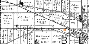
The Little Beaver Creek parallels on the south side of the bypass and crosses to the north side just west of the I-675 underpass. In the 1870’s this area was owned by John Coy on the west and Daniel Shoup on the east.
This section of road roughly follows the former route of the Baltimore & Ohio (B&O) railway. This was a narrower gauge rail, meaning the tracks were closer together. Nearby were the tracks that accommodated the Dayton and Xenia Traction line, the second generation of trolley cars that ran from Xenia into Preble County as well as from Dayton to Troy and Springfield.
 Area Growth
Area Growth
Area Growth
 B&O Railroad Medallion
B&O Railroad Medallion
B&O Railroad Medallion
 John Coy
John Coy
John Coy
 Jed's and the Mouse That Roared
Jed's and the Mouse That Roared
Jed's and the Mouse That Roared
 Whiskey Train
Whiskey Train
Whiskey Train
https://beavercreekliving.com/book/itemlist/user/23-brettwilliford?start=130#sigProId2413bf82e7

Loose pets and stray animals are becoming an almost daily feature on the local news and social media like The Beavercreek Buzz (our favorite!). Most are innocent escapees on an exploratory mission around the neighborhood, although unlike Disney movies, sometimes forget the way home. Others, fortunately none locally, end up on the first minutes of a the five o'clock news following an attack or on a late night TV commercial with Sarah McLachlan music playing in the background.
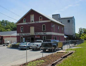
As you continue south on North Fairfield Road, you can clearly see Daytona Mills on your left. Daytona Mills continues as a business today!
Hidden in the woods immediately south of the creek is the location of the Schantz-Hagenbuch buildings just described. Turn right onto Research Boulevard/S.R. 835. At the stop sign turn left onto the S.R. 835 bypass / Research Blvd.

In 1921 the Hagenbuch’s sold the mill building to Ben Belden; he moved it piece-by-piece to the north side of the creek and switched it to electric power. The original building still stands and is known as the Daytona Mills. In the mid-1940’s, long before the development of the Coy Homestead Estates neighborhood, the original Jacob Coy cabin was purchased by Mrs. F.H. Hagenbuch and moved to their property and lovingly restored to period.
Navigation
Latest Blog Posts
- Just Don't Call Us Late For Dinner...
- Remember When...
- What A Long, Strange Trip It's Been...
- Snow Down = Slow Down
- School Bus Safety - Just Do It!
- Stevenson Road Covered Bridge
- Our Road Crews Are Worth Their Salt!
- The Most Colorful Of Seasons!
- Popcorn Fest! - Then And Now
- Pre-School Paradise!
- Remembering Riffles
- Ten Year Anniversary Of The Beaver Statues
Featured Image