Displaying items by tag: Beavercreek
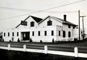
Next door to the Lone Pine was a supper club that was popular with local couples. In the mid-late 1940's it was a member's only establishment known as the Midnight Sun that allegedly offered some less-than-legal casino gaming. Stories have been shared that once or twice a year the Midnight Sun would be visited by the county law for an 'off-the-books' tax collection. In the 1950's it was open to the public as the Alpha Supper Club.
The building later played host to the VFW until they built across the street, and reportedly the Alpha Baptist Church held services there until their building on Beaver Valley Road was complete.
In the image, the road just visible ot the right of the image is Beaver Valley Road heading north from Dayton-Xenia. Looks like someone heading westbound on Dayton-Xenia struggled with the turn a bit, taking out a section of staves from the picket fence... more than one person has suggested it was likely Wendell 'Wendy' Marshall.
 Cyphers Marshall Accident
Cyphers Marshall Accident
Cyphers Marshall Accident
 Midnight Sun Ad 1
Midnight Sun Ad 1
Midnight Sun Ad 1
 Midnight Sun Ad 2
Midnight Sun Ad 2
Midnight Sun Ad 2
 Midnight Sun Ad 3
Midnight Sun Ad 3
Midnight Sun Ad 3
https://beavercreekliving.com/beavercreek-blog/itemlist/tag/Beavercreek?start=40#sigProIdc9153342b6

In what is now the parking lot of the Wellington Grille was a seedy little roadside tavern known as the Lone Pine.
Stories have said that the Lone Pine was a fairly rough place that had a number of cabins behind that would often be rented nightly by those traveling the rail lines. They were also available weekly or monthly. Local ministers would inventory the vehicles in the parking lot during the weekend and then make mention of their findings at Sunday's service!
The county Sheriff once reported that he was tiring of collecting drunks, alive and otherwise, from in and around the cabins. A young lady was murdered in one of the cabins in the late 1940's, which was the end of the rentals...
The Lone Pine was later as The Road Runner. Typically, the person who managed the Lone Pine lived in a small home that was located between it and the supper club next door.
I have to share that in meetings with local senior citizens for the development of this project, the mere mention of the Lone Pine would bring about a wide range of emotion, from embarassment of it's existence to the occasional wry grin.
 The Lone Pine Cabins
The Lone Pine Cabins
The Lone Pine Cabins
 Knife Fight At The Lounge
Knife Fight At The Lounge
Knife Fight At The Lounge
 Lone Pine Ad 1
Lone Pine Ad 1
Lone Pine Ad 1
 Fires At The Lone Pine
Fires At The Lone Pine
Fires At The Lone Pine
 Suicide Pact
Suicide Pact
Suicide Pact
 Lonesome Pine Filling Station
Lonesome Pine Filling Station
Lonesome Pine Filling Station
 Lone Pine Ad 3
Lone Pine Ad 3
Lone Pine Ad 3
 Lone Pine Ad 2
Lone Pine Ad 2
Lone Pine Ad 2
https://beavercreekliving.com/beavercreek-blog/itemlist/tag/Beavercreek?start=40#sigProId59ce7ee58a

Life throughout Beavercreek Township during the latter nineteenth century was very agrarian, even in an urban metropolis like Alpha! While many families were very self-sufficient, growing their own crops and raising their own livestock, this was a transitional period for American capitalism. There was no 'free lunch', even amongst friends and family! From Daniel Overholser's writings, we've learned how different interpersonal relationships were:
- When invited to a friend's home for dinner, guests left a proportionate share of the cost of the meal for their hosts - typically $.75 to $1.50 per couple.
- If borrowing a neighbor's wagon to haul a load of fence rails from the sawmill, a rental fee was paid.
- Trading and bartering was commonplace, but written notes were exchanged upon incurring the debt, and destroyed upon satisfying it.
Familes certainly looked out for their own, but the church and community received a great deal of attention as well:
- During the Civil War, communities were able to raise 'subsciptions', which were essentially early war bonds. When reaching their township quota, families within were exempt from sending their youth to support the war effort. Often the entire town would show up at the Alpha or Xenia train stations to greet returning soldiers.
- Church wasn't a Sunday only activity. It was common to attend Bible study at the member's church, as well as to travel to local kindred churches. There was certainly more than a fair share of rivalry amongst churches 150 years ago as well!
- More recently, fire struck the Beaver Grill - many from the community gathered lumber and converged on the site to begin the rebuilding of the local icon.
One of Beavercreek's greatest attributes even today is our sense of community! When one of our residents suffers a loss or tragedy, we rise up to support them.

At the northwest corner of this intersection stands a home that was formerly Benham School #4. The original structure is still intact and can clearly be seen in the current residence at the location.
 Benham School #4 As A Residence
Benham School #4 As A Residence
Benham School #4 As A Residence
 Benham School #4 As A Residence
Benham School #4 As A Residence
Benham School #4 As A Residence
https://beavercreekliving.com/beavercreek-blog/itemlist/tag/Beavercreek?start=40#sigProId05f9b6028a

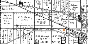
Heading south on North Fairfield Road, through Apple Valley, brings you into the 3,000 acres (4.6 square miles!) of the Coy family, its patriarch Jacob emigrating to America in 1757 and settling in the Beavercreek area after several of his children had grown and married. The log home they constructed in 1827 was moved and preserved and still stands in Beavercreek today near the Hagenbuch residence as previously described. The home originally stood southeast of Kirkmont Church on the Coy Homestead, while Coy cemetery is located adjacent to the west side North Fairfield Road just south of the Shakertown intersection.
The configuration of Shakertown Road in the image above has changed, but you can get a small glimpse of the reach of the Coy family. Many of the Coy descendants married and stayed locally, and the Coy name is prevalent throughout the township!
Here is a biography of Jacob Coy, Jr., believed written in 1888:
Jacob Coy, retired farmer, Alpha, is the oldest living settler in this township. He was born in Frederick County, Maryland, in 1792, being a son of Jacob and Susana Coy, who were born in Germany. They, with their parents, came to America when yet young, and while on the voyage, Jacob's parents died and were buried in mid-ocean. Their effects were confiscated by the ship's crew, and their children, seven in number, were thrown upon the shores of a new world penniless, in consequence of which they were sold to pay transportation. He (Jacob) was eighteen years old at the time, and labored six years for a Pennsylvania planter to free himself and younger brothers and sisters. He afterwards located in Maryland, where he was married, and lived a number of years, accumulating three hundred and fifty acres of land. When married he borrowed the money to cover necessary expenses. In 1800 be immigrated to Ohio, coming down the river to Cincinnati, where he stopped two months. Then there were only sixteen low log cabins in the place. He was importuned to stay, but pushed his way by team and wagon to Greene County; their way was cut through the woods in advance of the teams, and were eight days in coming. He purchased three thousand acres of land, all in a body, and erected a small log cabin, into which he moved his family. Two kegs of nails used in the erection of the cabin, were brought from Cincinnati on horseback, by young Jacob, our subject, for which twelve and one-half cents per pound were paid. Here Jacob Coy, Sen., lived and died, his death occurring in 1835 or 1836, at the age of ninety-three years. His wife died about 1840, aged eighty-three years. They were parents of twelve children, all dead except Jacob, who was the youngest. They were members of the German Reformed Church of many years standing. Jacob was eight years old when his parents landed in Ohio, and distinctly remembers counting the houses in Cincinnati, and says he has gathered hazelnuts where the city of Dayton stands. He has seen many hardships, and often working till midnight in burning brush; he has hauled flour from Cincinnati for $2.50 per barrel; wheat was sold for twenty-five cents per bushel, corn ten cents, coffee seventy-five cents per pound, and of the latter, three or four pounds did an ordinary family a year. He labored on the farm for his father till of age, when he began life for himself, but remained with his aged parents, to whom he was much attached, caring for then while they lived. On the old home farm he has lived four score years, and witnessed all the great changes that have transformed the wilderness to a garden of peace and plenty. In 1813 he was married to Barbara, daughter of Leonard Snypp, who bore him twelve children, five living; Peter, Henry, Adam, Leonard, and Susana. The deceased were, Rebecca, Catherine, Sarah, Jacob, David, Anna, and an infant. Mrs. Coy died in 1859 or 1860. Both were members of the German Reformed Church, having joined after their marriage. He has served as elder and deacon for twenty years. In politics he is a Republican, and during his long life has failed but once to cast his ballot for the benefit of that party.
Learn more about Jacob and his descendants on this family geneaology page. There's a lot of great information with the links on the page.

Turn right onto Patterson Road. Both homes at 3927 and 3928 E. Patterson Road date to c.1900 and were on Shoup land. On the right at 3827 E. Patterson Road is the Daniel Shoup House. This Vernacular style all-brick home was started in 1857 by Solomon Shoup and completed by his son Daniel in 1858.
The home and 200 acres were assumed later by Arthur Shoup, Daniel’s son, who was a progressive farmer for his day; incorporating crop rotation. He was the first dairy farmer in the area to employ an automatic milking machine. Unlike his father and grandfather, he did not pursue the tradition of being a minister in the German Reformed (Dunkard) Church.

At the four-way stop sign we have three points of interest; the northeast corner is the former site of the Lammer’s Chemical Company (The Barrel Factory) that exploded on September 30, 1969. The primary function of the company, as explained, was to chemically and mechanically clean 55 gallon barrels for re-use.
This Super-8 video of the fire was shot by Robert Deals and is narrated by Kip Smith, a battalion chief with the Beavercreek Fire Department.
This is probably the single biggest 'Where were you when...' in Beavercreek for the current generation. Amazingly, no deaths or significant injuries occurred during the explosion, although several firefighters were treated during the multiple day event. There are so many stories of families bringing lawn chairs nearby to watch the fire... exploding barrels launching thousands of feet into the air... globes on street lights melting from the heat... please add yours to the 'Comment' area below.
The fire reportedly started when a young man driving a forklift had a barrel he was carrying slip between the forks. The resulting arc ignited the barrel, causing him to jump from the forklift. It subsequently drove into a group of uncleaned barrels which grew the blaze - ultimately resulting in massive explosions of the pressurized chemical tanks on site.
The company operated as a chemical recycling facility from 1953 until 1969. During its operation, the facility maintained above-ground storage capacity of over 500,000 gallons as well as a number of vertical tanks, several transport trucks and semitrailers, and approximately 6000 55-gallon drums. The site was located on a two-acre parcel of land, and was divided into north and south portions by Little Beaver Creek. The facility burned to the ground in September, 1969.
 Lammer's Fire
Lammer's Fire
Lammer's Fire
 Barrel Factory Clean-Up #1
Barrel Factory Clean-Up #1
Barrel Factory Clean-Up #1
 Barrel Factory Clean -Up #2
Barrel Factory Clean -Up #2
Barrel Factory Clean -Up #2
 Barrel Factory Clean-Up #3
Barrel Factory Clean-Up #3
Barrel Factory Clean-Up #3
 Barrel Factory Clean-Up #4
Barrel Factory Clean-Up #4
Barrel Factory Clean-Up #4
 Barrel Factory Clean-Up #5
Barrel Factory Clean-Up #5
Barrel Factory Clean-Up #5
 Barrel Factory Clean-Up #6
Barrel Factory Clean-Up #6
Barrel Factory Clean-Up #6
 Barrel Factory Clean-Up #7
Barrel Factory Clean-Up #7
Barrel Factory Clean-Up #7
 Lammer's Mushroom Cloud
Lammer's Mushroom Cloud
Lammer's Mushroom Cloud
 The Barrel Factory - Post Fire #1
The Barrel Factory - Post Fire #1
The Barrel Factory - Post Fire #1
 The Barrel Factory - Post Fire #2
The Barrel Factory - Post Fire #2
The Barrel Factory - Post Fire #2
https://beavercreekliving.com/beavercreek-blog/itemlist/tag/Beavercreek?start=40#sigProId5f0b342bf8
Xenia Gazette columnist Joan Baxter wrote the following remembrance piece in 2016
The Fire At Lammer's Barrel Factory
At the corner of Patterson and Shakertown Roads in Beavercreek, many years ago there was a company which provided chemical recycling and barrel reconditioning. Although it did not manufacture barrels, most folks referred to the business as the “Barrel Factory.” It was a landmark for several years and since it was the site of one of the largest fires in the history of the county, the site though no longer used by that business is still remembered.
The Lammers Factory, often known as the Kohnen-Lammers Factory was owned by Anthony Kohnen and Paul Lammers. The business was in operation from 1953 to Oct. 7, 1969 when the fire occurred. The tower of flame which erupted from the site could be seen for several miles. The newspapers reported that people as far away as Springfield, Vandalia and West Carrollton could see the flames, and certainly, folks in Beavercreek and Xenia were able to see the fire.
News media appeared very quickly on the scene and several residents elected to drive to the scene to view the fire firsthand causing a terrible traffic jam. This made it more difficult for neighboring fire and police personnel to get to the scene to help. It was reported that cars parked in the median or on the side of the road on US Route 35 in order to observe what was happening.
The business actually was involved in the cleaning and reclamation of industrial solvents. Several types of chemicals were stored at the factory, including lacquer thinner and alcohol. Because of the nature of the business, thousands of barrels were stacked on the property, and from this comes the title barrel factory.
Apparently the fire broke out just before 6 p.m. on a loading dock where workmen were unloading drums containing solvents, then apparently spread to three nearby trailers loaded with drums and barrels.
Soon the two-story brick factory building and hundreds of barrels stored on the two and one-half acre property were enveloped in flames.
The Beavercreek Fire Department was under the direction of Chief T.E. (Bud) Crawford at the time. This was entirely a volunteer organization. There was no central water supply and no fire hydrants from which to draw water to fight the fire, so that when the water in the tanker trucks ran out, the trucks had to be taken away to be refilled. This was a time-consuming chore whichallowed the fire to spread even more.
There was another problem with the tanker trucks. Not all the hose connections were the same size so that if a pumper truck ran out of water and another took its place the hose might not fit.
The black smoke rose into the sky. According to a report in the Xenia Daily Gazette, Taylor Holland of Beavercreek saw the smoke column as he was driving away from Wilmington about 8:30 p.m. He said, “It was a very black sheet of smoke. As I got closer to Xenia, I could see the flames billowing into the sky. I guessed right that the barrel factory was burning.”
The flames continued to rise through the early hours of the evening. More than a dozen fire departments, perhaps as many as 20 from neighboring communities rallied to help0. The flames were so hot the firemen could not get close. Barrels exploded all evening long, some hurtling high in the air before landing back on the ground.
Beavercreek fireman Lt. Larry Vogel was injured when a drum exploded and engulfed him in flames. Fortunately the fire gear he was wearing kept him from more serious injury. Lt. Howard Geradine and Majusick of Mad River Township each received leg injuries. Fortunately there were no more serious injuries.
The fire began to come under control after about five hours when Dayton and Wright-Patterson fire trucks spread foam. Since there was no real way to fight the factory fire, water was sprayed on neighboring businesses which included three service stations and an animal hospital in the attempt to protect them from the flames.
Chief Crawford said, “Drums were flying all around. Men would hear an explosion and run, looking up in the air to see what was coming down on top of them.”
Finally the fire was out, and only the charred remains were left. Nearby service stations had plate glass windows cracked, and paint on the buildings was blistered. Street lights nearby melted on their poles from the heat and gasoline tank hoses were burned. At the Apple Valley Animal Hospital, a sign on the front caught on fire; heat charred the front door and broke the plate glass window. Even the draperies were scorched from the heat. Fortunately, the staff was able to move the animals to the back of the building away from danger. Power lines and telephone lines were burned through. Grass and shrubbery was scorched for hundreds of feet around the area.
The next morning the chemical smell was strong in the area. Thousands of blackened barrels littered the ground. In the center of what was left of the factory two giant tanks remained. Three burned out tanker trucks were amidst the rubble and the fire still smoldered.
The company had suffered a previous loss in November 1963 from a considerably smaller fire with damages estimated to be about $10,000. The estimates for the 1969 fire ranged from $400,000 to $500,000.
Joan Baxter is a local resident and a long-time historical columnist.

Continue through the four-way stop at Shakertown Road. The land around you has been owned by the Miami Valley Research Foundation for decades in the hopes of growing the Research Park area near the Bergamo Center. Recently, the large tracts have gone up for sale with the Bethel Christian Assembly of God buying the first at the northeast corner of the intersection. This area will change tremendously over the next decade for certain.
At the base of the hill on the west stands a residence at 945 Grange Hall Road that has had many additions over the years. The central building, visible by the chimneys found at either end, was the original Brown School #1. On the opposite side of the road and block further north at 1024 Grange Hall Road is the second, larger Brown School #2 – also now converted to a residence.
 Brown School #2 Now
Brown School #2 Now
Brown School #2 Now
 Brown School #1
Brown School #1
Brown School #1
 Brown School #2
Brown School #2
Brown School #2
https://beavercreekliving.com/beavercreek-blog/itemlist/tag/Beavercreek?start=40#sigProIdfe9ef72a6f

Head north on Grange Hall Road and note the beautiful brick homestead of the John Archer family on the west side of the road, originally built by a member of the Darst family in 1841. The east end of the wooded lot across the road was one of two stone quarries operated by the family. Quarries then were either a hand-dug gravel pit or an open creek bed where limestone slabs were extracted for the construction of foundations and cellars.
In the image above, the quarries are the crescent-shaped hash marks.
 Mr. and Mrs. John Archer
Mr. and Mrs. John Archer
Mr. and Mrs. John Archer
 Darst-Osborne House Marker
Darst-Osborne House Marker
Darst-Osborne House Marker
https://beavercreekliving.com/beavercreek-blog/itemlist/tag/Beavercreek?start=40#sigProId8425f43002

 Tragedy struck this very spot on November 2, 1959 when an F-104 Starfighter lost power and crashed into the former schoolhouse that had become the residence of Grace Shoup and her family. Grace, who ran from the home with her clothing afire, later died from her injuries. Daughters Lynn and Lora were killed in the crash. Ten year old Billy and eight year old Tommy Shoup were at school and learned of the devastation to their family as news spread through the community.
Tom Shoup graduated from BHS in 1969, his father owned Shoup Sporting Goods in the Knollwood area. A recollection has been shared of the tail section of the plane sitting in the middle of the burned wreckage that used to be the home.
 The Journal Herald Article #1
The Journal Herald Article #1
The Journal Herald Article #1
 The Journal Herald Article #2
The Journal Herald Article #2
The Journal Herald Article #2
 Tragedy
Tragedy
Tragedy
 Grace Shoup
Grace Shoup
Grace Shoup
 F-104 Starfighter Stock Image
F-104 Starfighter Stock Image
F-104 Starfighter Stock Image
https://beavercreekliving.com/beavercreek-blog/itemlist/tag/Beavercreek?start=40#sigProId575aad4a19
Editted Text of the November 3, 1959 Journal Herald article:
'A jet Starfighter crashed broadside into a house near here today and buried itself in the ruins. Two young sisters were killed. The pilot ejected to safety. The mother of the girls, Mrs Grace Shoup 37, ran from the house her clothing in flames after the supersonic craft crushed the house and exploded. She is in critical condition. The sisters were Lynn Shoup 12 and Laura 2. Their brothers, Billy 10 and Tommy 8, were in school. Lynn a was to have reported for her half-day session of school at noon. Their father was at work.
Wallace McCormick 27, was driving past the house when the plane hit. Flames from the blast shot clear across the road more than 50 feet away and enveloped my car, he told newsmen. The fire was all over the car could feel the heat. I lost control and hit the ditch about 50 yards down the road. When I got a look at the house it was a complete wreck and Mrs Shoup was running cross the yard with her clothing afire. McCormick was uninjured. Shaken neighbors beat out the flames and hustled the screaming woman to a hospital. The pilot, Maj James W Bradbury 34, ejected at low altitude when his craft lost power on takeoff. The house, a converted brick school building, is located about eight miles south of Air Force Base where Major Bradbury is based. Major Bradbury is one of the few men to survive ejection from a Starfighter one Air Force source said.

The Cherry Hill nursery once stood where the Cherry Hill shopping center now stands. Ahead on the left was Riffle’s Carry Out, a neighborhood grocer, sandwich shop and center of political debate operated by the Reid and subsequently the Hamlin families.
As you approach the intersection of Grange Hall Road, this loose-knit area was known as Concord. The northwest, pie-shaped portion of the intersection was the location of the Concord Meeting House, a church as well as Concord School #1.

The Greene Town Center on the south side of Indian Ripple Road Was once a large orchard owned for generations by the Spigler family. The mall was completed in the mid-2000’s. On the north side is the Crestview Nursing Home, which was damaged by a tornado in 1963. Several orchards lined Indian Ripple Road as you head east on lands that were farmed by the Prugh and Benham families, both now closely associated with Kettering.
In the image above, The Greene would be located just north of P. Baker's home. Indian Ripple Road was not yet cleared, but will later connect with Grange Hall Road at the upper right of the image.
https://beavercreekliving.com/beavercreek-blog/itemlist/tag/Beavercreek?start=40#sigProId425e8d7191


Continue south on County Line Road to the intersection of Indian Ripple Road. Large landowners in the area during the 1870’s were the Stutsman, Real and Darst families.
A quick little aside, near the intersection of Woodman Drive and Dorothy Lane to the west of here once stood a town named Beavertown. The Beavertown Cemetery off of Valleywood Drive is the final resting place of many early Beavercreek Township settlers. Beavertown was likely the closest town for many in the southwestern part of Beavercreek Township as well as those in southeastern Van Buren Township (Kettering). If you enjoy searching for old headstones, add the Beavertown cemetery to your list.

Soon you’ll approach one of the large tracts of another respected dairy farm; a HUGE 495 acre operation owned by John Moler. You’ll find his beautiful 1856 Federal style mansion at 2544 County Line Road. Mr. Moler’s children expanded the dairy operation into Montgomery County, eventually opening Moler’s Dairy, a popular ice cream and dairy store that survived into the 1970’s!
https://beavercreekliving.com/beavercreek-blog/itemlist/tag/Beavercreek?start=40#sigProId43c2b3b1e5


On the east side of County Line Road you’ll find Mount Saint John, a 150-acre Marianist property where the Bergamo Center resides. The original 80 acres of Mount Saint John were Shaker lands purchased by the Marianists in 1910. The Marianist Environmental Center is an organization dedicated to increasing awareness of the Earth and natural resources by sustaining appreciation for its preservation.

Welcome to Shakertown! The Shakers were a religious sect that practiced celibacy, communal living and equality of the sexes in their leadership. The actual name of the sect was The United Society of Believers in Christ’s Second Appearing, but they became known as Shakers due to the energetic dancing included in their worship services. The community, named Watervliet, extended into both Montgomery and Greene counties and was founded by a wheelwright named John Huston.
The Shakers were significant contributors to early American life having invented the circular saw, flat broom and clothes pins. Locally they were respected as hard working, peaceful and sincere people, supporting their commune with produce farming, the packaged seed industry, and Shaker-style furniture. Their 160 acre tract in Greene County was primarily located along County Line Road at the current locations of the Mount St. John / Bergamo Center and the Research Park lands.

The northeast corner of this intersection was the location of the Dayton and Xenia Traction Power Station. Part of the building may have survived to become a portion of the Lammer's Chemical Company, also impactful to Beavercreek's more recent history - but more on that in a bit!
Please turn right at the stop sign onto Patterson Road. The field on your left was once a huge apple orchard. This stretch of East Patterson Road provides some of the most beautiful autumn colors during ‘Peak Week’ – typically late October or early November. The home at 4362 East Patterson Road dates prior to 1880 and was owned by John Moler – more on him in just a moment.
 Dayton and Xenia Traction Power Station
Dayton and Xenia Traction Power Station
Dayton and Xenia Traction Power Station
 Dayton Xenia and Belpre Railroad Stock
Dayton Xenia and Belpre Railroad Stock
Dayton Xenia and Belpre Railroad Stock
 Rapid Transit Company Transfer Ticket
Rapid Transit Company Transfer Ticket
Rapid Transit Company Transfer Ticket
https://beavercreekliving.com/beavercreek-blog/itemlist/tag/Beavercreek?start=40#sigProIde8b5d4c7d3

The second, and more successful mass transit line was The Dayton and Xenia Traction Company, although there were numerous owners and names that followed. We'll refer to this company as 'The Traction' as it was 100+ years ago. Carrying its first passengers on January 23, 1900, its route cut through farmland, roughly following Main Street out of Xenia to Trebein, south of the railroad tracks.
It looped to the south side of the town of Alpha, followed the train tracks to Shoup's Station and ultimately to this point (the car barn was located at the site of Lyndon's Automotive on the southeast corner), the location of the car barn and power station. From here, it proceeded west via Watervliet, Wayne Ave., Phillips Avenue and then Wyoming Street to South Main Street in Dayton.
To stop the trolley, one just stood by the side of the track and signalled the oncoming trolley with a wave of the hand.
Per Elizabeth Shoup-Belden: "January 29, 1900, the noon car on its route to Dayton had failure of air brakes when going down Phillips Avenue hill jumped the tracks at the foot of the hill. There were about twelve passengers aboard. Among the passengers were two young ladies, very close friends, who had boarded the trolley at Alpha. These two, Mill Hallie Klunk and Miss Jeanette Hagenbuch, were seated together, Hallie by the window. When the trolley left the track, Miss Klunk was thrown through the window and fatally injured. Miss Hagenbuch was miraculously saved, receiving only minor bruises.
Mr. Fred Hawker, a farmer living near Alpha, was also fatally injured. There were other serious injuries, especially the motorman, but all recovered."
 Passenger Traction Car
Passenger Traction Car
Passenger Traction Car
 Passenger Traction Car and Barn
Passenger Traction Car and Barn
Passenger Traction Car and Barn
 Freight Traction Car
Freight Traction Car
Freight Traction Car
 View of Traction barn
View of Traction barn
View of Traction barn
 Pre-Paid Freight Coupons
Pre-Paid Freight Coupons
Pre-Paid Freight Coupons
https://beavercreekliving.com/beavercreek-blog/itemlist/tag/Beavercreek?start=40#sigProId11a8d05973

Turn left onto Grange Hall Road. Beyond the driveway at the south side of Carter Lumber is a long fencerow and path heading east, this was the B&O rail line. To the west it follows the 835 bypass and crosses Spaulding Road at the southern s-curve. Once over the Little Beaver Creek Bridge, pause at the stop sign onto Patterson Road.
The initial mass transit system between Dayton and Xenia was The Rapid Transit Company. In operation from approximately 1898 to 1908, this company literally operated on tracks imbedded into the compacted 'Old Route 35', now known as Dayton-Xenia Road. It left Xenia via N.Detroit Street to Fairgrounds Road, then cutting through a valley to Trebein. From there it followed Dayton-Xenia Road all the way into Dayton. An electric trolley system, the power station was located at Lucas' Grove Park, now Kil-Kare Race Park. The line struggled due to its rough road bed and eventually became unprofitable, leading to its early demise. If you'd like to tour one of the Rapid Transit rail cars please visit Carillon Park in Dayton - it's worth the price of admission!
The Little Beaver Creek parallels on the south side of the bypass and crosses to the north side just west of the I-675 underpass. In the 1870’s this area was owned by John Coy on the west and Daniel Shoup on the east.
This section of road roughly follows the former route of the Baltimore & Ohio (B&O) railway. This was a narrower gauge rail, meaning the tracks were closer together. Nearby were the tracks that accommodated the Dayton and Xenia Traction line, the second generation of trolley cars that ran from Xenia into Preble County as well as from Dayton to Troy and Springfield.
 Area Growth
Area Growth
Area Growth
 B&O Railroad Medallion
B&O Railroad Medallion
B&O Railroad Medallion
 John Coy
John Coy
John Coy
 Jed's and the Mouse That Roared
Jed's and the Mouse That Roared
Jed's and the Mouse That Roared
 Whiskey Train
Whiskey Train
Whiskey Train
https://beavercreekliving.com/beavercreek-blog/itemlist/tag/Beavercreek?start=40#sigProId2413bf82e7
Latest Blog Posts
- Just Don't Call Us Late For Dinner...
- Remember When...
- What A Long, Strange Trip It's Been...
- Snow Down = Slow Down
- School Bus Safety - Just Do It!
- Stevenson Road Covered Bridge
- Our Road Crews Are Worth Their Salt!
- The Most Colorful Of Seasons!
- Popcorn Fest! - Then And Now
- Pre-School Paradise!
- Remembering Riffles
- Ten Year Anniversary Of The Beaver Statues
Featured Image